M Molvray & P Kores: Photos of Wildflowers, Nature, and Biology
Links
MMolvray: contact
PKores: home
Albums
California-South-Coast-Mts
2203
Satwiwa
99
Serrano-Canyon
79
Pt Mugu b Jan16-Feb13
164
Pt Mugu c Feb14-Mar15
142
Pt Mugu d Mar16-Apr30
134
Pt Mugu e May
285
Pt Mugu f Jun
215
Pt Mugu g Jul-Aug
57
Pt Mugu h Sep-Oct-Nov
68
Pt Mugu a Dec01-Jan15
75
Springs-Fire-aftermath
243
Rose-Valley-Ojai
10
Matilija-2004-04
10
Camino-Cielo-and-Chumash-Painted-Cave
91
Circle-X-Ranch
19
Mishe-Mokwa
66
Sandstone-Peak
161
Kanan-Zuma-Canyon
46
Solstice-Canyon
26
Triunfo Canyon
9
China-Flat-Simi
19
Santa-Susana-Mts
110
Angel-Vista-Las-Robles-Trails
57
Charmlee-SP
5
Carrizo-Plain
12
California-deserts
1605
California-everything-else
1602
New-Zealand
1778
Papua-New-Guinea-1970s
59
Fiji
63
Botanical-Gardens-Aquariums
546
Moorpark
427
hummingbirds
68
orchids
401
plovers shorebirds
105
garden
345
sky
35
tech-science-fiction
81
other-places-and-plants
107
Bryophytes
538
Fungi Lichens --Mushrooms
57
US-other-states
201
9645 photos
Specials
Most visited
Recent photos
Recent albums
Random photos
Calendar
Menu
Tags
(20)
Search
About
Notification
OSWORLDMAP
Identification
Login
Quick connect
Username
Password
Auto login
Home
/
California-South-Coast-Mts
/
Pt Mugu a Dec01-Jan15
/
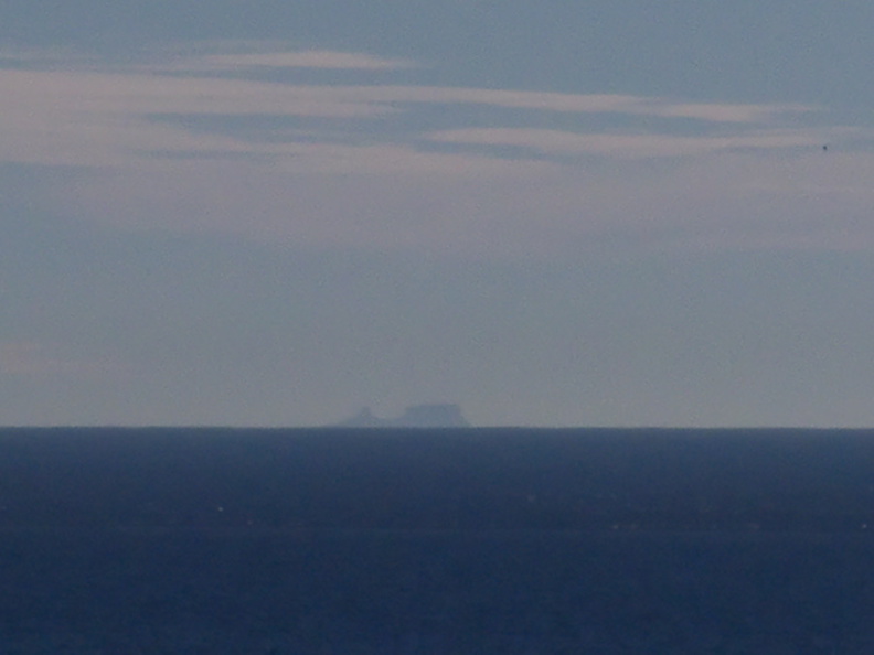
Santa-Barbara-Island-projected-through-temperature-inversion-Chumash-2013-12-12-IMG 3094
2/75
Thumbnails
Previous
Next
Photo sizes
Photo sizes
✔
XXS - tiny
(240 x 180)
✔
XS - extra small
(432 x 324)
✔
S - small
(576 x 432)
✔
M - medium
(792 x 594)
✔
Original
(900 x 675)
slideshow
Show file metadata
download
IPTC Metadata
iptc_caption
Powered by
Piwigo
)
)
)
)
)