1453/2071
)
)
)
)
)
)
)
)

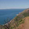
On the horizon, that's the peninsula of Palos Verdes on the south side of Los Angeles.

- latitude
- 34.067788888889
- longitude
- -118.91593611111
- iptc_caption
- On the horizon, that's the peninsula of Palos Verdes on the south side of Los Angeles.